Social Sciences > EXAM > PHSC 211 Chapter 9 Quiz (Fall 2019)– Liberty University (A grade) (All)
PHSC 211 Chapter 9 Quiz (Fall 2019)– Liberty University (A grade)
Document Content and Description Below
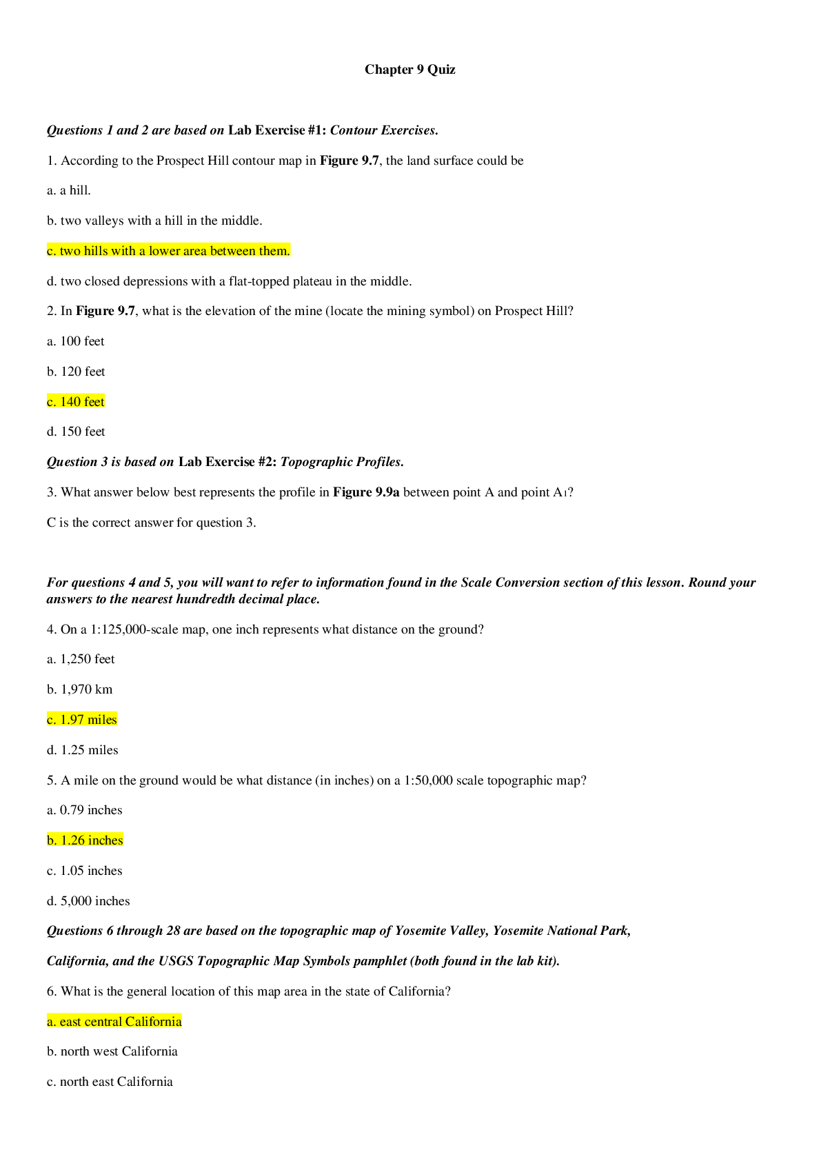
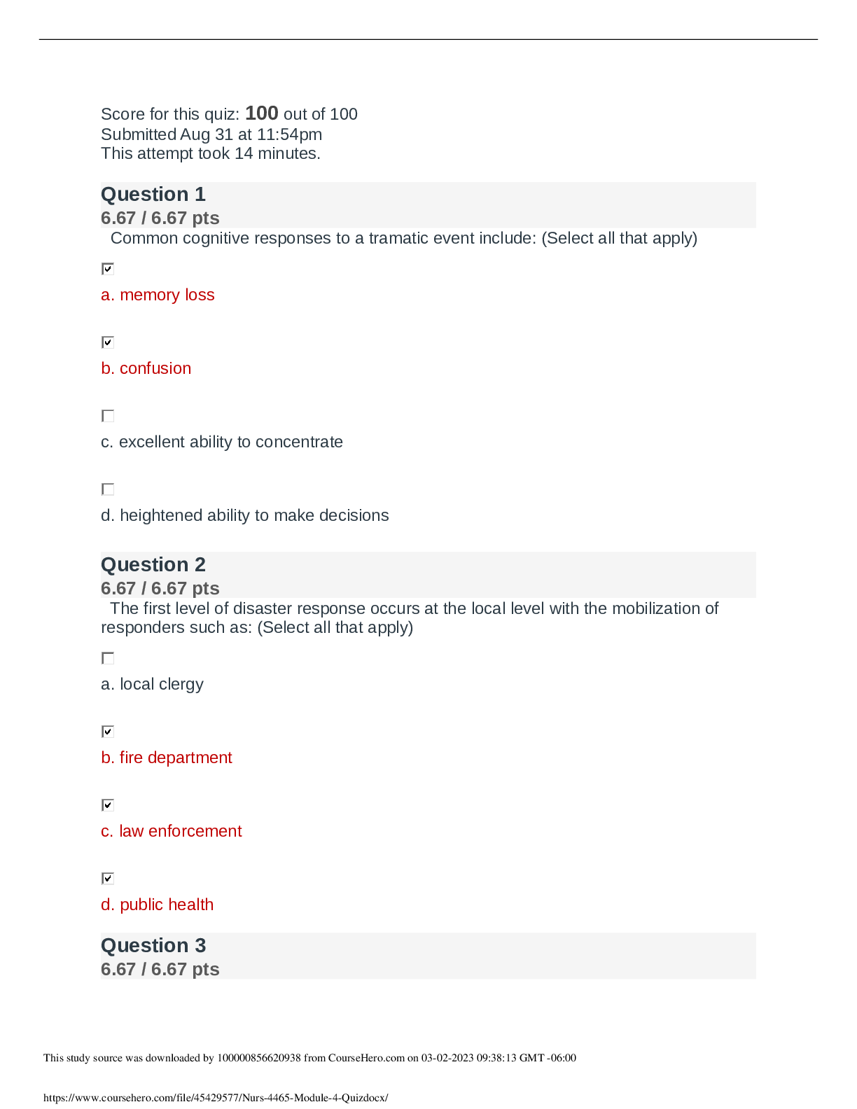
PHSC 211 Chapter 9 Quiz (Fall 2019)– Liberty University (A grade) Questions 1 and 2 are based on Lab Exercise #1: Contour Exercises. 1. According to the Prospect Hill contour map in Figure 9.7, the ... land surface could be a. a hill. b. two valleys with a hill in the middle. c. two hills with a lower area between them. d. two closed depressions with a flat-topped plateau in the middle. 2. In Figure 9.7, what is the elevation of the mine (locate the mining symbol) on Prospect Hill? a. 100 feet b. 120 feet c. 140 feet d. 150 feet Question 3 is based on Lab Exercise #2: Topographic Profiles. 3. What answer below best represents the profile in Figure 9.9a between point A and point A1? C For questions 4 and 5, you will want to refer to information found in the Scale Conversion section of this lesson. Round your answers to the nearest hundredth decimal place. 4. On a 1:125,000-scale map, one inch represents what distance on the ground? a. 1,250 feet b. 1,970 km c. 1.97 miles d. 1.25 miles 5. A mile on the ground would be what distance (in inches) on a 1:50,000 scale topographic map? a. 0.79 inches b. 1.26 inches c. 1.05 inches d. 5,000 inches Questions 6 through 28 are based on the topographic map of Yosemite Valley, Yosemite National Park, California, and the USGS Topographic Map Symbols pamphlet (both found in the lab kit). 6. What is the general location of this map area in the state of California? a. east central California b. north west California c. north east California d. south central California 7. Using the USGS Topographic Map Symbols pamphlet in the laboratory kit, what type of lake is Starr King Lake on the USGS Yosemite Valley topographic map? a. annual lake b. perennial lake c. intermittent lake d. dry lake 8. What parallel marks the northern limit of the topographic quadrangle map? a. 119° 45' N b. 119° 29' 10" N c. 37° 42' N d. 37° 47' 05" N 9. What meridian is the eastern limit of the topographic quadrangle map? a. 119° 45' E b. 119° 29' 10" W c. 37° 42' W e. 37° 47' 05" E 10. What is the magnetic declination of the topographic quadrangle map? a. 10.5° east b. 15.5° west c. 17.5° east d. 20.5° west 11. In what year was the magnetic declination measured? a. 1927 b. 1955 c. 1958 d. 1970 12. This topographic quadrangle map was compiled from aerial photographs taken in a. 1927. b. 1955. c. 1958. d. 1970. 13. What is the fractional scale of the topographic map? a. 1/12,000 b. 1/24,000 c. 1/62,500 d. 1/250,000 14. How can the ratio scale of this map be expressed as a verbal scale? a. 1 inch = 1,000 feet b. 1 inch = 2,000 feet c. 1 inch = 1 mile d. 1 inch = 4 miles 15. Using the bar scale provided in the map margin, measure the length of the southern boundary of the topographic map from El Portal to Merced Peak. The distance in miles is about a. 5 miles. b. 9 miles. c. 14.5 miles. d. 18.5 miles. 16. Why are there so many curves and switchbacks in the Glacier Point Road? a. The slope is relatively flat and the curves give people more time to look at the scenery. b. The slope is steep and the curves force traffic to move at a slower pace. c. The slope is steep and the curves make the road safer and easier to drive. d. The curves keep vehicles from the edges of the cliffs. 17. What direction does the Merced River flow through the valley floor from Sentinel bridge to El Capitan Bridge? a. southwest b. northeast c. southeast d. northwest 18. Starr King Lake drains in which direction? a. northwest b. northeast c. southwest d. southeast 19. Which of the following areas of Yosemite Valley appears to be the steepest? a. Inspiration Point b. Rockslides c. Ribbon Meadow d. Middle Brother 20. Identify the section, township, and range for Elephant Rock. a. Sec. 36, T.2S, R20E b. Sec. 35, T.2S, R21E c. Sec. 2, T.3S, R20E d. Sec. 2, T.3S, R21E 21. What is the contour interval of the USGS topographic map of Yosemite Valley in your lab kit? a. 20 feet b. 40 feet c. 100 feet d. 200 feet 22. If you were a casual recreational hiker with young children, which of the following trails would be least strenuous for a leisurely family outing? a. Merced Lake Trail b. Mirror Lake Loop Trail. c. Tenaya Lake and Tuolumne Meadows Trail d. El Capitan Trail 23. What mountain, peak or dome has the highest elevation point on the topographic map? a. Half Dome b. Clouds Rest c. Basket Dome d. Sentinel Dome 24. What is the elevation of the lowest point benchmark “BM” on the topographic quadrangle? a. 3,182 feet above sea level b. 3,227 feet above sea level c. 3,419 feet above sea level d. 3,438 feet above sea level 25. What is the total relief within the topographic quadrangle map? a. 5,615 feet b. 6,018 feet c. 6,507 feet d. 6,699 feet 26. The approximate shortest road miles distance from Yosemite Lodge to Mirror Lake is _______miles. (Use your ruler or protractor to measure and calculate the approximate distance in miles. Remember 1 inch equals 2,000 feet.) a. 1 mile b. 3 miles c. 5 miles d. 6 miles 27. How long is the Wawona Tunnel just north of Inspiration Point on Wawona Road? a. 3850 feet b. 4250 feet c. 4600 feet d. 4800 feet 28. What is the quadrant bearing from the first “L” in Lost Lake to the “Q” in Quarter Domes near the east end of Yosemite Valley topographic map? a. 35º b. N35ºE c. 45º d. S45ºE Questions 29 and 30 refer to “The Geological Story of Yosemite Valley,” which can be found on the back of the USGS Yosemite Valley topographic map. 29. What type of rock did the glaciers and Merced River excavate to form Yosemite Valley? a. granite b. sandstone c. shale d. quartzite 30. What is the shape of the Yosemite Valley, which is typical of glaciated valleys? a. V shape b. U shape c. W shape d. S shape 31. [Show More]
Last updated: 1 year ago
Preview 1 out of 5 pages
Reviews( 0 )
Document information
Connected school, study & course
About the document
Uploaded On
Oct 13, 2020
Number of pages
5
Written in

Additional information
This document has been written for:
Uploaded
Oct 13, 2020
Downloads
0
Views
123
.png)

.png)