Geography > EXAM REVIEW > University of British Columbia - ATSC 113ATSC-113-Final-Exam Review (All)
University of British Columbia - ATSC 113ATSC-113-Final-Exam Review
Document Content and Description Below
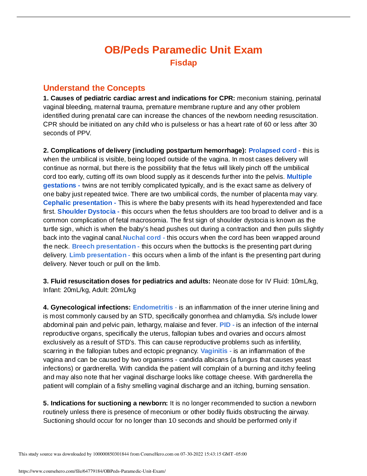
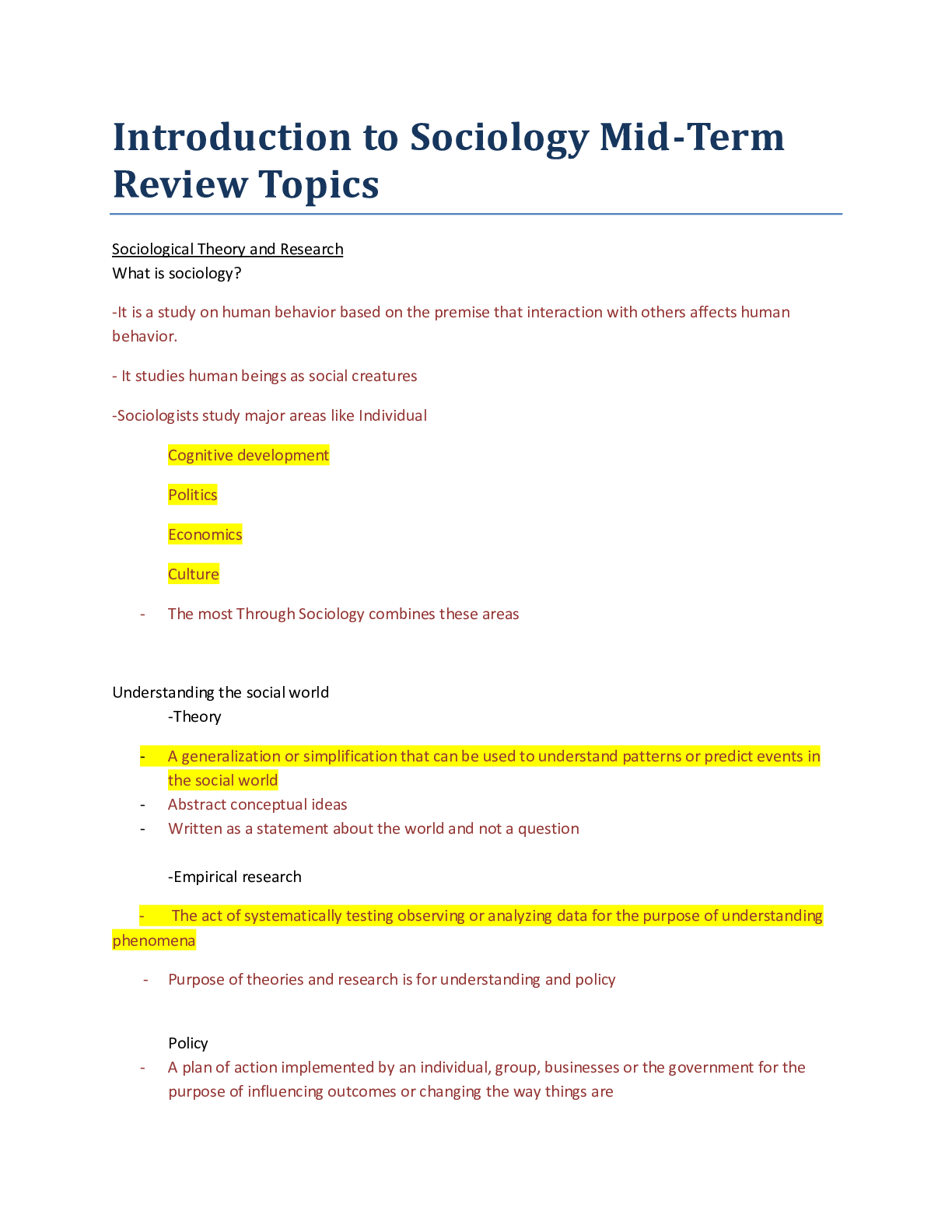
ATSC 113 – Final Exam Review Flying Module Clouds, Ceilings, Visibility, and Fog Normal clouds are classified into 2 categories: - 1. Convective Clouds / Cumuliform Clouds (Cu) o Loo... k like stacks of cotton balls - 2. Layer Clouds / Stratiform Clouds (St) o Look like sheets or blankets Convective Clouds / Cumuliform Clouds (Cu) - Forms when warm humid air rises through cooler surrounding air in the atmosphere o Buoyancy associated with warm air drives strong updrafts - Often have relatively flat bases that are somewhat near to the ground - Come in 4 different sizes: o 1. Small Cumulus Humilis (Cu hum) o 2. Medium Cumulus Mediocris (Cu med) o 3. Large Cumulus Congestus (Cu cong) or Towering Cumulus (TCu) o 4. Extra Large Cumulonimbus (Cb) or Thunderstorms When do Convective Clouds form? - Wherever the air at ground level is colder than the ground or ocean-surface What are the local effects from Convective Clouds? - There is usually an updraft that starts near ground level and extends up into the cloud o Therefore, glider pilots circle in updrafts to get free lift to higher altitude - There are also weaker downdrafts in between these updrafts o therefore, pilots feel a bumpy ride as they feel updrafts + downdrafts What are the hazards associated with Convective Clouds? - Bigger convective/cumuliform clouds have stronger updrafts o Cumulus congestus and thunderstorms have violent updrafts and can cause damage to the aircraft Layer Clouds / Stratiform Clouds (St) - Forms when warm air slides up along the top surface of cold air and condenses, typically occurring at warm fronts - Classified by their altitude (3 categories): o 1. High Cirrus (Ci), Cirrostratus (Cs), and Cirrocumulus (Cc) o 2. Medium Altostratus (As) and Altocumulus (Ac) o 3. Low Stratus (St) and Nimbostratus (Ns) What are the order of clouds you see? - You will see the highest clouds first, then mid-level clouds, then the lowest ones last o This is because the higher the clouds are, the more extended they are What is the difference between a Stratus and a Nimbostratus cloud? - Nimbostratus o Precipitating; therefore, have diffuse cloud bases - Stratus o Is not precipitating; therefore, have well defined cloud bases What are the hazards associated with Layer Clouds / Stratiform Clouds? - Once inside the cloud, pilots cannot see the ground or landmarks - When cold enough, ice may form along the edges of the aircraft o But unlike Convective Clouds / Cumulus Clouds, they are not turbulent Special clouds are categorized into 4 categories: - 1. Clouds in Unstable Air Aloft o Castellanus Look like castle turrets; small diameter Indicates that the atmosphere is becoming unstable o Billow (K-H) Clouds Look like parallel bands of clouds, such as billows Indicates wind shear and clear-air turbulence - 2. Clouds Associated with Strong Winds Across Mountains o Lenticular (Mountain-Wave) Clouds Look like a hat or cap on the mountain Indicates vertical wind oscillations o Rotor Clouds Looks ragged and turbulent; typically under smoother-looking lenticular clouds Indicates severe turbulence at low altitudes from mountain waves o Banner Clouds Look smokey and is found along the side of a mountain Indicates strong turbulence touching the downhill side of a tall, isolated mountain peak - 3. Clouds Formed by Extra Heat, Updrafts, or Turbulence o Pyrocumulus Looks like a poof of explosion; typically grey-brown in colour Indicates a forest fire so strong that the heat and moisture released can make a thunderstorm in the smoke o Pileus Looks like a small, short-lived scarf above a cumulus cloud Does not indicate anything o Fractus / Scud Look very ragged and occurs at low-altitudes only Indicates high humidity and strong winds - 4. Clouds Formed by Humans o Fumulus Looks like smoke, created from factories and towers Does not indicate anything o Contrails Looks like a long narrow spiral from aircrafts/jets Indicates the turbulent wing-tip vortices behind aircrafts Cloud Ceiling - Height above ground level of the lowest cloud base o Must be below 20 000 ft or 6000 m o Must cover more than half of the sky; therefore, must be “broken” or “overcast” How can we determine ceiling altitude? - Laser ceilometers What does it mean to see the word “visibility” without any adjectives in front? - It means “Horizontal Visibility” Horizontal Visibility - How far away you can see in front of you - Poor Horizontal Visibility? o You cannot see the ground, landmarks, or other aircrafts o You cannot see the horizon, so it is hard to keep the plane level o You cannot see the runway at the airport Vertical Visibility - The limit that you can see vertically - Poor Vertical Visibility? o Limits runway acquisition Runway Visual Range (RVR) - Indicates how far ahead a pilot can see along a runway centerline - Only reported when visibilities are poor Visual Flight Rules (VFR) - You fly by mostly looking out the window; therefore, you require good visibility and need to stay out of clouds - What is Visual Flight Conditions (VFC)? o Horizontal Visibility: Must be 3 statue miles or more (preferably 5 statue miles or more) o Ceiling: Must be 1000 ft. above the airport (preferably 3000 ft. above the airport) Marginal VFR (MVFR) - Conditions where VFR is allowed but visibility is poor o Horizontal Visibility: Between 3-5 statue miles o Ceiling: Between 1000 ft. – 3000 ft. above the airport Instrument Flight Rules (IFR) - You conduct most of the flight by not looking out the window; therefore, you use tools and displays - What is Instrumental Flight Conditions (IFC)? o Horizontal Visibility: Less than 3 statue miles o Ceiling: Less than 1000 ft. above the airport o Bad weather is called Instrument Meteorological Conditions (IMC) which is weather that VFR flight is not allowed When does fog form? - Location o Many fogs form in low spots or in valleys - Humidity o Forms when there is high humidity - Temperature o When unsaturated air is cooled to its dew-point temperature (temperature at which water vapour starts to condense into liquid droplets) - Winds o Forms when winds are relatively slow or near calm - Cloud-cover o Forms when there is less cloud cover, so ground can be cooled and cool the air above it How does fog affect aviation? - Fog is an obscuration that reduces horizontal visibility o Prevents pilots from seeing where they are going o Prevents weather observers from seeing the sky condition and weather above the fog What are different types of fog? - Radiation o Cool ground cools the air that touches the ground and as night progresses, fog gets deeper - Advection o Humid air blows over a colder surface, causing the air temperature to decrease to dew-point temperature - Upslope o Air is pushed upward when wind blows air against a hill slope and if it gets sufficiently cold, then fog can form - Precipitation/Frontal o Formed by adding moisture via evaporation - Steam o Occurs when cold air moves over warm humid surfaces like unfrozen lakes or oceans during early winter Obscurations - Smoke o Comes from factories, cars, and forest fires Reduces visibility and makes it hard to breathe - Volcanic Ash o Very abrasive, like sandpaper Can cause bearings and gears to wear-out very quickly and to fail or seize Clogs and contaminates various filters and ventilation systems Reduces visibility and adds weight to aircraft - Blowing Sand and Dust o Haboobs: sand storms, created by outflow winds from thunderstorms Abrasive effect on aircraft and engines and reduces visibility o Dust storms occur when turbulent winds are present Reduces visibility - Haze o Consists of microscopic liquid water droplets that form around a pollutant particle that attracts water vapor, so it grows even in low humidity Reduces visibility - Blowing Snow o Blizzard: blowing snow in the air with fast wind speeds Reduces visibility and can cause “white outs” where everything is white - Rain o Has limited horizontal extent Reduces visibility Pressure, Temperature, Winds, and Wind Shear Pressure + Altitude - Pressure decreases smoothly with increasing altitude Density + Altitude - Air density decreases smoothly with increasing altitude How does reduced oxygen at high altitude affect pilot physiology? - Causes hypnoxia o Symptoms: Between 12 000 – 15 000 feet • Impaired judgment, memory, alertness • Headache, drowsiness, dizziness Above 15 000 feet • Periphery vision fails • Cyanosis: lips and fingernails turn blue • Unconsciousness and then death o The higher altitude you fly, the shorter your time-duration of useful consciousness (TUC) is ::::::::::::::::::::::::::::::::::::::::CONTENT CONTINUED IN THE ATTACHMENT::::::::::::::::::::::::::::::::::::::::::::::::::: [Show More]
Last updated: 1 year ago
Preview 1 out of 45 pages
Reviews( 0 )
Document information
Connected school, study & course
About the document
Uploaded On
Feb 07, 2021
Number of pages
45
Written in

Additional information
This document has been written for:
Uploaded
Feb 07, 2021
Downloads
0
Views
79
 (1).png)
.png)
.png)