Geography > QUESTIONS & ANSWERS > GIS QUESTIONS AND ANSWERS 100% PASSS (All)
GIS QUESTIONS AND ANSWERS 100% PASSS
Document Content and Description Below
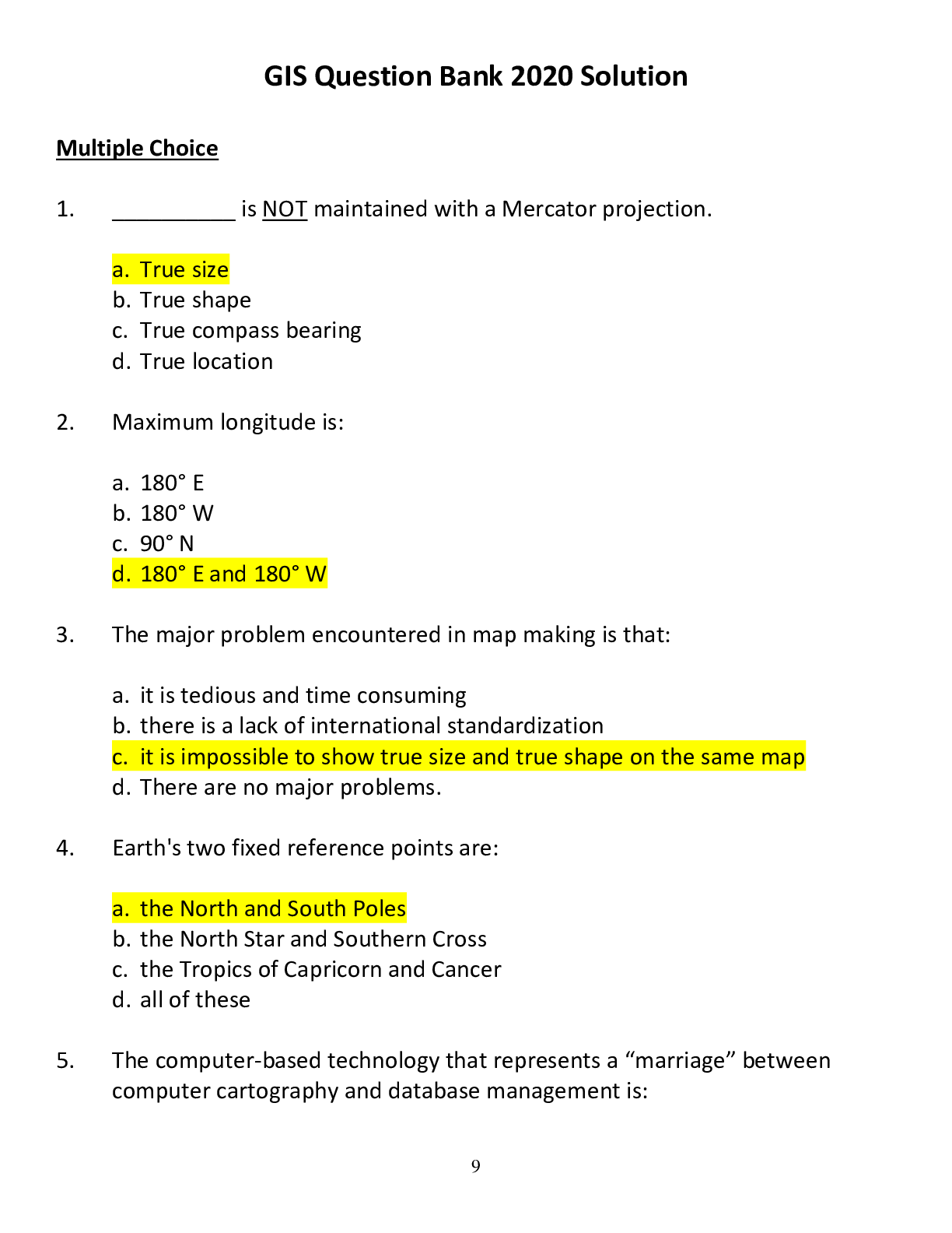
GIS Question Bank 2020 Solution Multiple Choice 1. __________ is NOT maintained with a Mercator projection. a. True size b. True shape c. True compass bearing d. True location 2. Maximum lo... ngitude is: a. 180° E b. 180° W c. 90° N d. 180° E and 180° W 3. The major problem encountered in map making is that: a. it is tedious and time consuming b. there is a lack of international standardization c. it is impossible to show true size and true shape on the same map d. There are no major problems. 4. Earth's two fixed reference points are: a. the North and South Poles b. the North Star and Southern Cross c. the Tropics of Capricorn and Cancer d. all of these 5. The computer-based technology that represents a “marriage” between computer cartography and database management is: 10 a. spatial analysis b. geographic information system (GIS) c. spectral analysis d. multi-spectral scanning 6. A map capable of showing true direction is called a(n): a. focal map b. planar map c. Mercator map d. Azimuthal map 7. Perhaps the most important development in remote sensing techniques in the last 40 years has been: a. aerial photography b. SONAR c. Earth-orbiting satellites d. Side-looking RADAR (SLAR) 8. Cartography is the science of: a. surveying b. navigation c. map making d. data collection 9. Maximum latitude is reached at the: a. Prime Meridian b. North and South Poles c. Tropics of Capricorn and Cancer d. Equator 10. The circle of illumination divides Earth into two hemispheres known as: 11 a. east and west b. north and south c. day and night d. summer and winter 11. The Mercator map is actually a __________ type of projection that has been mathematically derived. a. conical b. cylindrical c. planar d. interrupted 12. A small-scale map: a. shows small areas of Earth's surface b. includes greater detail c. has a small denominator in its representative fraction d. all of these e. none of these 13. Latitude measurement __________ as one moves away from the equator. a. increases b. decreases c. does not vary d. none of these 14. Contour maps: a. provide the reader with an idea of the lay of the land b. are also referred to as "dot maps" c. show distribution of any feature on Earth's surface d. are used to show lines of equal temperature 15. A degree of latitude is subdivided into: 12 a. centitudes and millitudes b. hours, minutes, and seconds c. minidegrees d. minutes and seconds 16. Which of the following is an example of a verbal scale? a. 1:10, 000 b. 1 inch to 10 miles c. | —-| —-| —-| —-| —-| d. none of these 17. On a standard near-infrared (false-color) photograph or digital image, the color red represents: a. areas that are hot b. growing vegetation c. areas of barren land d. roads 18. In the Public Lands Survey System, one section equals: a. 36 square miles b. 6 square kilometers c. 640 acres d. all of these 19. Which of the following are advantages of remote sensing systems? a. They provide rapid, worldwide coverage of the environment b. They can easily acquire information on inaccessible locations c. They can be used to locate valuable natural resources d. All of these are correct. 20. The term "parallels" refers to: 13 a. lines of longitude b. lines of latitude c. lines of meridian d. great circle routes 21. One degree of latitude is approximately equal to: a. 7 miles b. 112 miles c. 69 miles d. 11.2 miles 22. One feature that is NOT an advantage of a map is: a. it is a distortion-free presentation of features and relationships on Earth's surface b. it can be reproduced easily and cheaply c. it can depict an area in various degrees of detail d. it is easy to handle and transport 23. Doppler weather radar systems are mainly designed to produce images of: a. wind speed and directions on clear days as well as stormy days b. precipitation patterns and amounts by seeing through clouds c. temperature patterns in the atmosphere d. All of these are correct. 24. Why are digital images generally used instead of photographs in satellite remote sensing? a. Digital image data can be beamed back electronically from space. b. Digital images are similar to a mosaic, made up of grid cells that form a picture. c. Digital images can reproduce a wider part of the spectrum than photos can. 14 d. Digital image data can be beamed back electronically from space, and they can reproduce a wider part of the spectrum than photos can. 25. A great circle: a. cuts Earth into two hemispheres b. is an exact circumference of Earth c. provides the shortest routes of travel on Earth's surface d. all of these 26. Persons traveling west across the International Date Line must: a. turn the calendar back one day b. turn the calendar ahead one day c. turn his watch 12 hours ahead d. turn his watch 12 hours back 27. Which of the following is NOT a benefit of a geographic information system? a. A GIS can store and display of many combinations of mapped data layers. b. A GIS can adjust data on different map scales and projections to fit one map. c. A GIS can be used to analyze the spatial distributions of environmental, natural, and human features. d. All of these are benefits that a GIS can provide. 28. Mercator maps show the greatest amount of distortion in the: a. polar region b. middle latitudes c. equatorial region d. Distortion is distributed evenly throughout the map. 29. The time of day when the sun reaches its highest position [Show More]
Last updated: 1 year ago
Preview 1 out of 29 pages
Instant download
Buy this document to get the full access instantly
Instant Download Access after purchase
Add to cartInstant download
Reviews( 0 )
Document information
Connected school, study & course
About the document
Uploaded On
Sep 22, 2021
Number of pages
29
Written in

Additional information
This document has been written for:
Uploaded
Sep 22, 2021
Downloads
0
Views
207
.png)
.png)
.png)
.png)
.png)
.png)
.png)
.png)
.png)
.png)
.png)


 answers.png)

 Coronary Artery Disease and Acute Coronary Syndrome.png)
.png)